THE south east quarter of Queensland is expected to receive some handy rain starting later in the week, well timed for early planted oats crops.
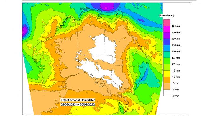
Bureau of Meteorology modeling shows 10-15mm falls over much of the Darling Downs, Wide Bay and Burnett, and in to lower Central Queensland.
Australia's official weather forecaster also says handy rain can be expected across the top of Cape York, the north of the Northern Territory, and a big areas in Western Australia, including the Kimberley.
Heavier falls are shown for north eastern and coastal NSW as well as Victoria.
However, much of the inland will continue to miss out, with only an at best, measly 1mm expected.

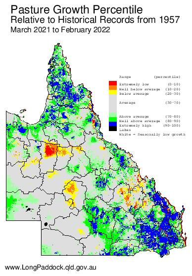
Despite the generally good season - particularly in the south east zone - parts of Queensland remain dry and even extremely dry in some districts.
The Queensland Government's pasture growth mapping shows extremely high and above average pasture growth in many areas of the state, particularly in the south east.
About half of Queensland is shown to have average pasture growth for the 12 month period, the LongPaddock mapping shows.
However, extremely low and well below average pasture growth is also evident on the map, particularly in parts of north west Queensland, the central west and significant areas of Central Queensland.

The good news is BOM's latest three month outlook issued on March 17 says April to June rainfall is likely to be above median for northern and eastern Queensland, the northern NT, and eastern coastal areas of NSW and Victoria.
BOM says there is also an increased chance of unusually high rainfall (in the top 20pc of historical records) for April to June across the northern tropics and most of the rest of Queensland, and small areas of western and coastal NSW.
Want daily news highlights delivered to your inbox? Sign up to the Queensland Country Life newsletter below.


